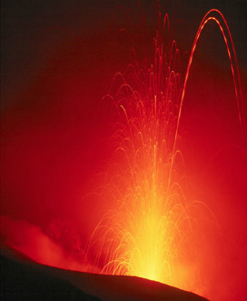
Popocatepetl is a 5,426m (the second highest peak in Mexico) tall stratovolcano (or composite volcano) located in Central Mexico. Though dormant for almost 50 years, since 1994 the volcano has been moderately active at frequent intervals, fitting the description for Strombolian activity; "Mildly explosive at discrete but fairly regular intervals of seconds to minutes". It's name derives from Nahuatl, spoken widely in Mexico today and by the Aztecs, and translates to "Smoking Mountain" - suggesting that the volcano was also mildly active for long periods several hundreds of years ago.

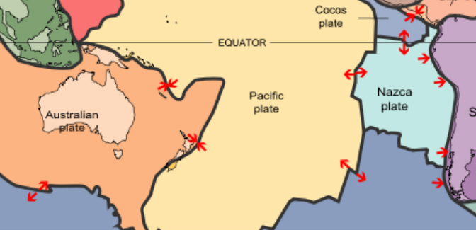
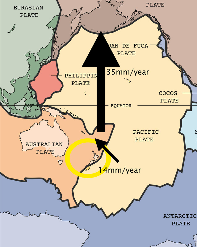
The volcano sits on the east end of the Trans-Mexican volcanic belt, an area of volcanic activity due to the subduction of the Cocos micro-plate being subducted beneath the North American plate at a rate of roughly 1.4 cm/year.

The volcano has formed as result of laying down of layers of volcanic material such as lava (molten rock), tephra (fragmented rock pieces), pumice (low density, lightly coloured volcanic rock) and volcanic ash over the volcano's estimated 730,000 lifetime. These layers, or strata, truly make the structure a composite one and build up to create the distinctive steep-sided conical form posessed by stratovolcanoes. Lava flows are relatively viscous due to a high silica content, hence flowing short enough distances down the volcano as to progressively increase its gradient.
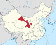
Above: Interactive map (google) showing the location of Popocatépetl.
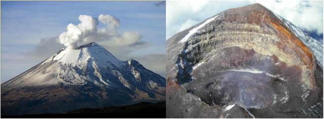
Below left: Side on view of the volcano, displaying steep sides.
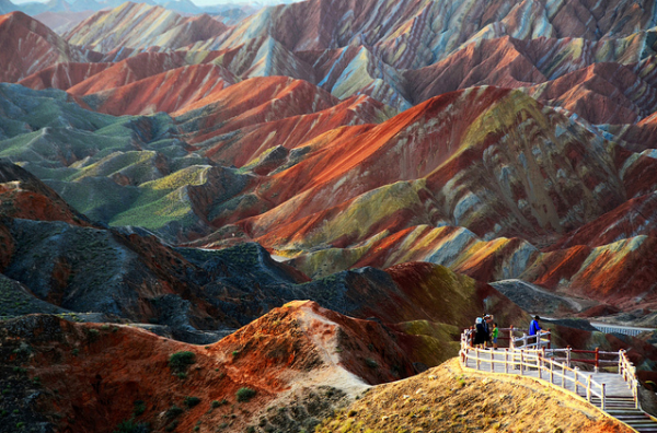
Below right: View into the volcano's crater, displaying clearly it's more recent strata.
Picture
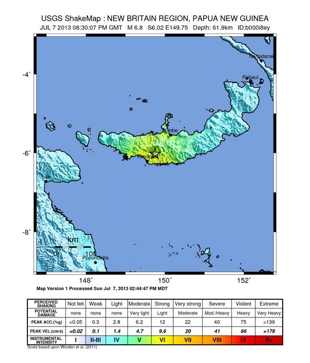
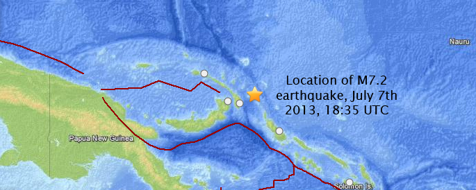
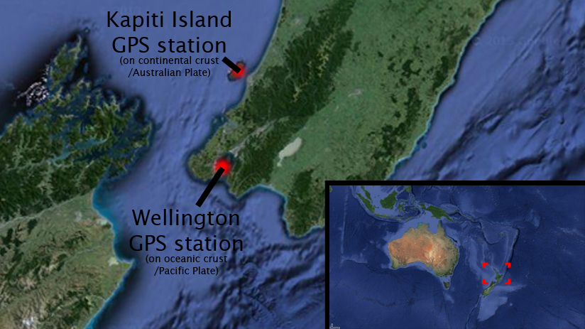
Just 70 km and within eyesight from Mexico City the volcano poses a large threat to the city's roughly 8.9 million inhabitants and constitutes a large concern for the local authorities. To quantify seismic risk, and to predict large eruptions the University of New Mexico has a seismic monitering station located nearby, indicated as a blue triangle on the image below.

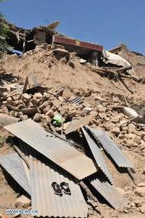
Though the volcano is unlikely to affect any settlements via its lava flows, which are too viscous to flow far (though 15 km flows have been recorded of other stratovolcanoes), or indeed it's lava bombs which are only possible of projection amounting to ~800 m laterally, the ash expelled into the atmosphere from eruptions has caused some minor disruption. There are several medium-sized settlements within 20 km of the volcano, such as Atlautla (17 km W), and Ecatzingo (15 km SW), that have experienced ashfall. The farthest reaching ash clouds have reached Cuernavaca, 65 km WSW of the volcano itself.

Earthquakes are a concern too, though recently Popocatépetl's seismic activity has only reached magnitudes of around 4.5 on the richter scale.
Picture
Above: Map showing location, magnitude and date of seismic activity. View source for updated data and key: http://www.iris.edu/seismon/zoom/?view=eveday&lon=-100&lat=17
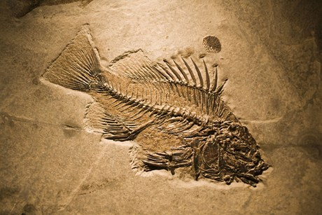
Below: Wegener's original publication describing continental drift; perfectally relevent.

References:

Popocatépetl background:
http://www.volcanodiscovery.com/popocatepetl.html
http://en.wikipedia.org/wiki/Popocat%C3%A9petl#Eruptions


Scientific background:
http://en.wikipedia.org/wiki/Stratovolcano
http://en.wikipedia.org/wiki/Strombolian_eruption
http://www.tectonics.caltech.edu/outreach/highlights/mase/
(interesting explanation of the mexican subduction zone)

Resources:
http://ofgs.aori.u-tokyo.ac.jp/~okino/platecalc_new.html (Relative plate velocity calculator)

Activity updates:
http://www.volcanodiscovery.com/popocatepetl/news.html
http://www.volcano.si.edu/weekly_report.cfm#vn_341090


Tom Ruddell, 28/8/13
Picture
 
On the 7th July 2013, within a two hour period two earthquakes of magnitude 7.2 and 6.6 on the richter scale struck the New Ireland Region, Papua New Guinea.

The first tremor occurred at 18:35 UTC (04:35 local time) and was of magnitude 7.2, but though there are about 16000 people living within 100 km little disruption was caused as the hypocentre was measured to be at a depth of roughly 380km.

The second earthquake was six times less powerful (M6.6) and had an epicentre located 500km from the first, putting it in the vicinity of 140,000 inhabitants. This earthquake was much more of a threat as it was only ~60km deep, though no damage has been reported.

Below: USGS shaking intensity map for the second earthquake. Colour key at the bottom.
At the destructive margin the Australia Plate is subducted beneath the Pacific plate at the New Britain Trench where it descends into the asthenosphere. It is here, in the Benioff zone that the first (M7.8) earthquake is thought to have originated - USGS commented that the great depth and seismic patter was likely to have resulted from "internal (intraplate) deformation of the subducted slab, rather than as an interplate event on the shallow plate boundary interface".

Had the earthquake originated from the interaction between the two plates the hypocentre would have been much shallower and a tsunami would likely have resulted. USGS issued a precautionary warning but said it was unlikely to occur.

Below: Location of the first M7.2 earthquake (red lines show margin types). Australian plate to south east; Pacific plate to north and west
If for any reason you'd rather hear an American man read a less comprehensive or scientific overview out to you, look no further:
References:
USGS (first earthquake hypocentre 378km deep)
http://earthquake.usgs.gov/earthquakes/eventpage/usb000i89z#summary

EMSC (first earthquake hypocentre 383km deep)
http://www.emsc-csem.org/Earthquake/earthquake.php?id=324993

http://earthquake.usgs.gov/earthquakes/eventpage/usb000i89z#summary

http://thewatchers.adorraeli.com/2013/07/07/very-strong-earthquake-m-7-2-struck-new-ireland-region-papua-new-guinea/

Thomas Ruddell, 25/07/2013
 
One of the most active volcanoes on the Kamchatka peninsula, "Shiveluch" (or Sheveluch), South Eastern Russia has been erupting recently. The volcano has had over 60 large explosions in the last 10,000 years with the most recent catastrophic eruption being in 1956. The volcano itself is 65,000 years old and is about 2,800 metres high.
Picture
Above: Location of the Kamchatka Peninsula
Below: Ash plume from the volcano caused by an eruption dated October 6th 2012.
Picture
The volcano is monitored by KVERT who have reported a viscous lava flow on the volcanoes North flank from 12-19 of July this year.

Klyuchevskaya Sopka, the highest of all the Kamchatka volcanoes at 4,750m above sea level, has also been active recently. On the 25th January 2013 a strombolian eruption was recorded, featuring the expulsion of some incandescent cinders and low-energy ejection of lava bombs.
Below: A strombolian eruption
Picture
Shiveluch lies on the Pacific ring of fire, an area surrounding the Pacific ocean with a large amount of tectonic activity, and is a UNESCO world heritage site. Shiveluch was formed as a result of a destructive plate margin between the Pacific and North American plates and is characterised as a stratovolcano otherwise know as a composite volcano.

The Aleutian ocean trench to the west of Kamchatka is the ocean trench from this plate margin, and can be seen clearly on the location image (three above).

Composite volcanoes are common at subduction zones and are particularly explosive. There is however little danger to the nearest settlement Klyuchi which is 50km away and is so small it could evacuate quickly in the case of a large eruption.
Above is a video of some recent activity during January this year. In fact the current eruptions are classified as being part of the same continuous eruption that started in 1999.
To finish, a slightly related song about the ring of fire (however not the Pacific one) from Johnny Cash.
Picture
 
China's Gansu province was hit by two quakes, the first being at 7:45 am local time today. Gansu province is a region of mountains, desert and pastureland in central North China. Despite the province being heavily populated with 26 million inhabitants the nearest city, Dingxi, has a less dense population of 2.7 million residents most of which are farmers.
Picture

The first earthquake measured 5.98 on the richter scale with the second being 5.6 in magnitude. According to the US Geological Survey the earthquake's hypocentre was 9.8 km deep and so was considered a shallow quake.
Tremors were felt up to 400km away including in the provincial capital of Lanzhou.

There have been 75 dead and 400 recorded injured so far with the Dingxi government claiming an economic cost of roughly £21 million. Over 380 houses have collapsed in Dingxi with 500 soldiers including 120 specialist rescuers being deployed to search the rubble.
 

Picture
The Gansu province is highlighted in red with the epicentre of the earthquake being in the centre of the southern most lobe.

The earthquake was most likely caused by the movement of crust at one of the numerous faults surrounding the Gansu region and much of China.
China has seen several earthquakes above magnitude 5.5 in recent years including the magnitude 7.9 quake in the Sichuan province which killed 90,000 in 2008.

The Gansu region is probably most famed for its 'colourful hills' at Danxia. These were formed as a result of sedimentary deposits of sandstone being weathered and coloured due to different mineral contents. Unrelated to tectonic activity however an interesting geological formation.
Picture
 
Introduction:
New Zealand sits right on the cusp of a plate margin between the Australian and Pacific plates. Both plates are moving in similar directions but at different speeds, and there there is a convergent relative velocity of 23mm/year between the plates, due to convection currents circulating towards each other.
Below: Diagram showing relative plate velocities, with proportional arrows
The result of this motion is that the continental Pacific crust is subducted below the continental Australian crust; as the Pacific plate descends into the Beniof zone it becomes locked with the underside of the Australian plate. Friction prevents slippage until the force becomes too much and the plates slide and move past each other. This particular event is known as a "slow release" earthquake as the plates slip past at a rate very little faster than those typically measured by GPS instruments in Wellington and Kapiti.

It is estimated that the earthquake is a 7 on the Richter scale, but is clearly far less destructive (I on Mercalli scale "Generally not felt by people unless in favorable conditions". Typical fast release M7 earthquakes would rank roughly X, described as "Many well-built structures destroyed, collapsed, or moderately to severely damaged"). The reason for the unusual devastation for an earthquake of such energy is that rather than the plates slipping over a period of days, in New Zealand the earthquake has been ongoing since January 2013 and "will most likely continue for several months".

The focus of the earthquake is only 40km below sea-level and acts in the vicinity of Wellington, a medium-sized city of 395,600 inhabitants.
Above: National and Local scale maps showing measurement of relative plate motion using GPS stations

Below: Cross section diagram of subduction
From the above diagram it is possible to conclude that the "North Island" of New Zealand, on which the activity has been registered, was formed by precisely the same tectonic margin over several thousands of years. The Island was formed by the upward crumpling of the sediments originally contained in a geosyncline below sea level. This is proved by the geology of New Zealand - predominantly Greywacke with many fossils of sea creatures. As a side note, melted sections of the subducted Pacific plate that have descended to the Beniof zone and below into the asthenosphere are melted by conductive heat from the mantle as well as friction with the Australian plate and pressure. The magma presently rises in its less dense state and results in a number of composite volcanoes around the area, explosive due to their high silica content and viscous magma.
Above: Well-preserved fossil of a fish found in Wellington, New Zealand


Sources:
Tectonic Plate velocity data:
http://www.edufy.org/content/show/48
Earthquake information, Subduction diagram:
http://info.geonet.org.nz/display/quake/2013/05/27/M7+slow+release+earthquake+under+Wellington
Location diagrams:
www.maps.google.com
Geological information:
http://www.teara.govt.nz/en/geology-overview
New Zealand fish fossil:
http://www.3news.co.nz/New-Zealands-Catalogue-of-Life/tabid/1160/articleID/254934/Default.aspx
Mercalli Scale:
http://en.wikipedia.org/wiki/Mercalli_intensity_scale

Thomas Ruddell, 19/07/2013

    Authors

    Josh Long studied geology at the University of East Timor, consequently completing a PhD in geology at the prestigious University of Panama.

    Tom Ruddell studied Geophysics with French at the University of Easter Island where he later did his PhD. Now editor of the National Geologic magazine.

    Adam Willis once picked up a rock and remarked "what the blazes is this?". An expert in the highly technical areas of Radish people and the pronunciation of German names, he has won several awards to commemorate his discoveries.

    Archives

    August 2013
    July 2013

    Categories

    All
    Earthquakes
    Volcanoes