On the 7th July 2013, within a two hour period two earthquakes of magnitude 7.2 and 6.6 on the richter scale struck the New Ireland Region, Papua New Guinea.
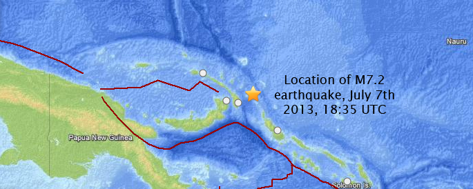
The first tremor occurred at 18:35 UTC (04:35 local time) and was of magnitude 7.2, but though there are about 16000 people living within 100 km little disruption was caused as the hypocentre was measured to be at a depth of roughly 380km.
The second earthquake was six times less powerful (M6.6) and had an epicentre located 500km from the first, putting it in the vicinity of 140,000 inhabitants. This earthquake was much more of a threat as it was only ~60km deep, though no damage has been reported.
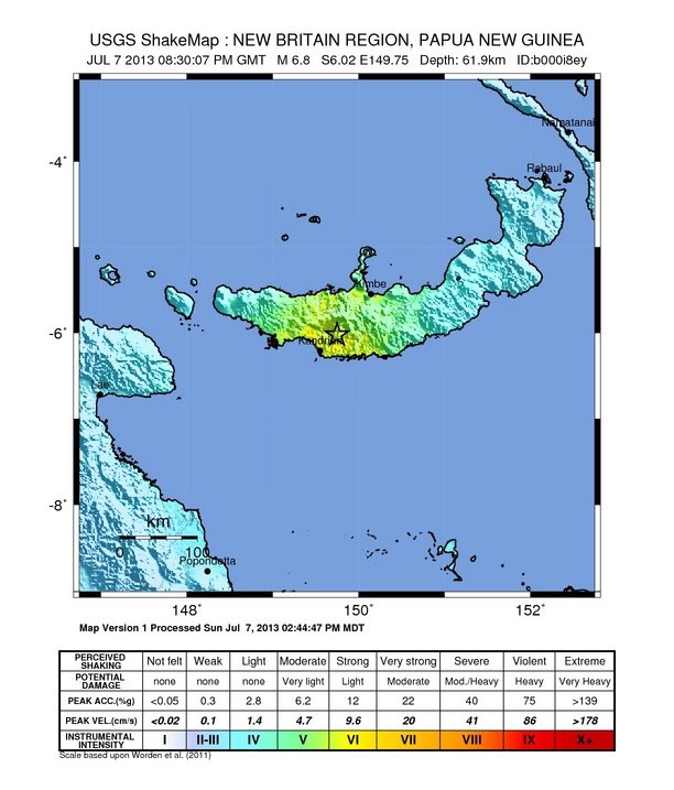
Below: USGS shaking intensity map for the second earthquake. Colour key at the bottom.
The first tremor occurred at 18:35 UTC (04:35 local time) and was of magnitude 7.2, but though there are about 16000 people living within 100 km little disruption was caused as the hypocentre was measured to be at a depth of roughly 380km.
The second earthquake was six times less powerful (M6.6) and had an epicentre located 500km from the first, putting it in the vicinity of 140,000 inhabitants. This earthquake was much more of a threat as it was only ~60km deep, though no damage has been reported.
Below: USGS shaking intensity map for the second earthquake. Colour key at the bottom.
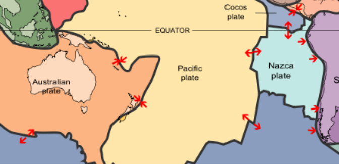
At the destructive margin the Australia Plate is subducted beneath the Pacific plate at the New Britain Trench where it descends into the asthenosphere. It is here, in the Benioff zone that the first (M7.8) earthquake is thought to have originated - USGS commented that the great depth and seismic patter was likely to have resulted from "internal (intraplate) deformation of the subducted slab, rather than as an interplate event on the shallow plate boundary interface".
Had the earthquake originated from the interaction between the two plates the hypocentre would have been much shallower and a tsunami would likely have resulted. USGS issued a precautionary warning but said it was unlikely to occur.
Below: Location of the first M7.2 earthquake (red lines show margin types). Australian plate to south east; Pacific plate to north and west
If for any reason you'd rather hear an American man read a less comprehensive or scientific overview out to you, look no further:
References:
USGS (first earthquake hypocentre 378km deep)
http://earthquake.usgs.gov/earthquakes/eventpage/usb000i89z#summary
http://earthquake.usgs.gov/earthquakes/eventpage/usb000i89z#summary
EMSC (first earthquake hypocentre 383km deep)
http://www.emsc-csem.org/Earthquake/earthquake.php?id=324993
http://earthquake.usgs.gov/earthquakes/eventpage/usb000i89z#summary
http://thewatchers.adorraeli.com/2013/07/07/very-strong-earthquake-m-7-2-struck-new-ireland-region-papua-new-guinea/
Thomas Ruddell, 25/07/2013

